Safety Standdown in Asheville

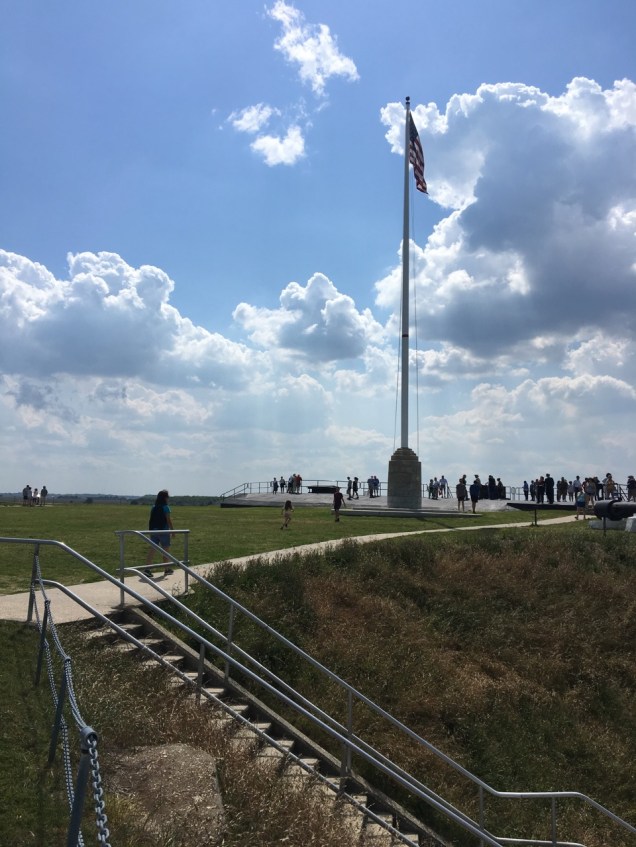
In Naval Aviation, Safety Standdowns are periodic events that are put together to help aviators optimize safety awareness while in flight and on the deck.  The Safety Standdown is a day where all aircraft remain on the deck and the entire squadron gathers together to hear or provide safety-related discussions on a wide range of topics (e.g. having a state trooper relate the importance of wearing seatbelts (I can attest to that!), an aerospace physiologist share the latest research on the systemic impact of sleep deprivation, etc.).

While all hands were usually happy to have a breather from the flight schedule, the day served to remind everyone that aviation is inherently dangerous and one must remain ever vigilant against complacency.  Invariably when one gets complacent checklist items are skipped, corners are cut, and mishaps can easily follow.  It is important to note that these day-long events were scheduled periodically, most often at times where complacency might be higher than usual.  Typically a Safety Standdown would occur half-way through deployment where many start to think, “We’ve got this…” as they switch to autopilot and become less mindful about operations.  Another optimal time was just before redeploying home when many minds have already shifted to reuniting with family members after the long separation and may be suffering from “Get-home-itis, ” where potential safety red flags might be ignored to avoid delaying homecoming.  And, of course, a Safety Standdown is an expected evolution following any mishap, be it crunching metal or injuring personnel.

As our current travels resemble a deployment more so than not (and I’ve already touched on the value of checklists), I had already noticed that in resuming our travels this phase we were maybe a little looser in following SOP than our prior journey. For example, the grey water drain valve had been left open following tank dumping procedures, which is no big deal really as it just meant Flight got his shoes washed with some soapy water while getting hooked up at our next campsite.  We had also missed setting a cotter pin on one side of our Blue Ox tow bar contraption, which meant that by the time we arrived at our next campsite one of the two larger pins that directly connect the Subaru to the Blue Ox tow bar had not been locked in place and had wriggled half-way free in transit.  Although our tow bar has safety cables in the event of such a mechanical disconnect, I’d prefer not to see them engaged.  You’d think that two seasoned naval aviators would take these signs of complacency for what they were and immediately debrief the possible consequences of departing from checklists, but we were too wrapped up in our deployment experience to make that a priority.  Shame on us.  Instead, our Safety Standdown was triggered by a mishap.

We departed Charleston at a most civilized hour entirely delighted by our introduction to this lovely city and meandered northwest to Asheville, NC.  After a stop at Congaree National Park (I’ll get to that shortly), we arrived at the Lake Powhatan Recreation Area & Campground and registered to get our lovely spot nestled in the trees.  Even if a spot is “drive through,” we tend to disconnect the Subaru and park it out of the way so I can help Flight maneuver Davista into the ideal location (depending on layout, water and electrical hook-up locations, view, obstructing branches, etc.) within our assigned spot.  Our Carpinteria episode taught us well.

Although the details of who discovered our blunder and when are open to interpretation, the upshot is that when either Flight or I opened the door to collect the hardware box used to store the Blue Ox tow bar connection gear and set the parking brake (that became SOP when we had forgotten to do so once early in our travels on a not so level road – yikes!), it was more than a little surprisingly to find it was already engaged.  My brain slowly leapt beyond the mildly befuddled observation “Well, that’s not supposed to be like that” to meet Flight’s “Holy crap.  How long has that been on?! “ to “Shoot – We likely no longer have a functioning Toad.”  !!!  I then cycled through today’s activities to try to pinpoint how we might have managed such an oversight.

Let me back up. Before departing Charleston, we had discussed making a stop at Congaree National Park, because it was so darn close to our intended path.  It was another opportunity to learn about the biodiversity of a pocket of our country we’d not yet seen and probably wouldn’t ever if we didn’t stop now.  Although it wasn’t as last minute an addition to our itinerary as the two stops I had suggested (insisted on?) from Tampa to Savannah, the conversation that followed that extended travel day was fresh in my mind, which meant I was keen to minimize the time of our layover at Congaree.  I guess you could say I was sporting my own variety of “Get-on-the-road-to-our-next-home-itis.”

Upon our arrival at Congaree, we noted that all the spots in the oversized parking lot big enough to accommodate our crazy 51’ road show were taken up by NPS vehicles far shorter than ours.  Dang it.  To fit in the remaining longer than normal spots without blocking traffic entirely, we had to disconnect the Subaru and take up two spots with our vehicles. Fortunately, Congaree was hardly slammed on this Tuesday afternoon and taking up an additional oversized spot with our regularly sized Subaru was entirely forgivable.

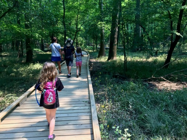
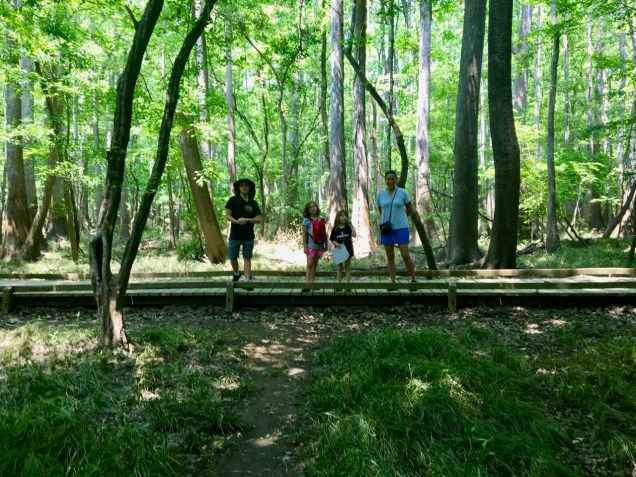
This particular National Park is an interesting mix of swamp, old growth bottomland hardwood forest, and more swamp.  While the Visitor Center boasts some great information about the native population and the push to preserve Congaree’s biodiversity, I was ever aware of our time on the road ahead of us and did my best to make our stop most expeditious.

When we collected Junior Ranger books (a theme, you might note), there was not a Ranger in site. Several volunteers were at the desk, but they were not official NPS Rangers.  We learned there was a proscribed burn underway (used to cull the dead undergrowth and help the forest rejuvenate), which is an all Ranger hands on deck evolution and closed off a good portion of the main boardwalk hike through Congaree. Led by our complaining bellies, we returned to Davista to have a sandwich lunch while we sorted out what the girls needed to do and how much of the requisite hike was possible/necessary to complete their requirements before we could be away.

IMG_2065.jpg

Hunger assuaged, we walked a mile along the boardwalk out to a short overlook peeking over a small, not particularly clean-looking, lake where we saw several turtles frolicking.

IMG_2100.jpg

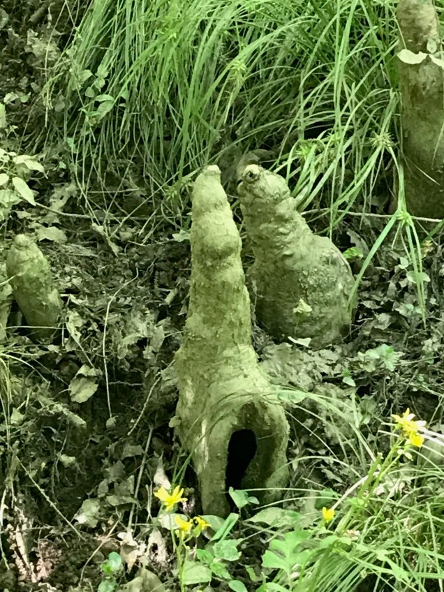
Along our boardwalk trek, we also saw some unique creatures, or evidence thereof.  I saw these houses (?) and had no idea what to make of them. I took this picture specifically to show the folks at the Visitor Center to ask what they were.

IMG_2071.jpg

The answer?  Crawfish chimneys.  Apparently crawfish build these towers and turn circles about in their mud structures to create a center hole vent to increase the oxygenation of the water in their homes.  Pretty savvy, those crawdads.  We also saw several blue-tailed skinks running about the forest.

IMG_2088.jpg

Running nowhere were the endless ranks of baldcypress knees, whose true purpose has yet to be identified.

IMG_2084

The baldcypress is a cousin to the magnificent redwood and enormous sequoia trees whose acquaintance we made last fall as we meandered through California.  Unique to these southeastern swamp dwellers, are flared out trunks serving to offer stability in the ever-changing water levels.  These buttressed stems provide the strength to resist additional stresses without a deep root system, which might actually suffocate the tree in the low-oxygen environment of a typically waterlogged swamp.  Early botanists thought the knees provided a means of additional oxygen exchange by elevating the roots above the standing water, I thought this one looked like a faerie house.

IMG_2081.jpg

That theory has since been disproven, so their true purpose remains one of the great mysteries of life.  Perhaps such existential rumination is what distracted me when we departed Congaree.

IMG_2664.jpg

After the girls were sworn in for their 20thJunior Ranger badges, we hightailed it to Davista and rapidly made ready for driving into the seasoned (meaning worn smoother by time than the newer more jagged ranges out west) mountains of North Carolina.  A quick refresher on the checklist for readers would be a good idea.

The Hitching Up the Toad checklist to date looked a little something like this:

  • Unlock Blue Ox Tow Bar from locked position (locked “up” so it doesn’t drag)
  • Reposition Blue Ox Tow Bar into Y in preparation for hook-up
  • Maneuver Toad into position (or Davista if doing so solo – says Flight ??!?!!)
  • Toad parking brake – set
  • Keys in ignition, set to detent position 1 to enable lights mimicking Davista’s
  • Grab plastic box holding connection hardware from Toad
  • Pin Blue Ox tow bar into left and right sides of Toad connection points
  • Set cotter pins left and right (to lock connection pins)
  • Connect dead-man’s switch (in case both the tow bar and the cables fail, engaging Subaru’s brakes should she run tether-free)
  • Connect safety tow cables beneath tow bars
  • Connect red electrical cable above tow bars
  • Return plastic box holding connection hardware to Toad passenger seat
  • Gear shift in neutral
  • Disengage the Subaru parking brake

All good, right?

In principle, yes, yet we neglected to identify who was responsible for executing the final steps.  I had assumed that Flight was checking the settings for the key in the ignition and verifying the parking brake was off and the engine was not in gear. Flight was under the assumption I was setting the key, disengaging the parking brake, ensuring the stick shift was out of gear and he would verify (position one, parking brake off, gear shift neutral).

And so we exemplified the saying “When you assume, it makes an ass out of you and me…” or at least it will burn out your Toad’s braking system.

Somehow, in our collective oversight, we missed that last step and dragged the Subaru behind us for 180+ miles with the parking brake engaged.  Oops.  The mechanic who outfitted us with new brakes informed us the old ones had gotten white hot during our travels from Congaree.  Flight and I realized that we have gotten off rather light by only having to purchase new brakes. The Toad could easily have burst into flames, but didn’t.  If we had lost our Toad, our journey would have come to a screeching halt.  As Flight is fond of saying, although averted for now, we could certainly see disaster from here.  Fortunately, it looked much less ominous through a pint of Sierra Nevada, and we settled into our Asheville time, our wallets a little lighter, but with brakes shiny and new.

South Cackalacky

I first heard that term from a salty Flight Engineer in my first squadron, in response to “where are you from?”  He was (is) deeply Southern and sharp as a tack, with a thick accent that tended to belie, or at least distract you from, his depth of knowledge and skill.  I’m pretty sure he did it on purpose; he liked to keep people off guard.

“South Cackalacky” sounded to me like a deliberate play on the redneck thing.  Owning it and throwing it back at you with pride.  Or something like that.  It wasn’t his invention of course, I’ve heard it used by many people in various contexts.  On the other hand, it’s not that old a term either, probably no older than the ‘70s/’80s.  A brief internet search on the term didn’t net much, other than the fact than older North/South Carolinans aren’t familiar with it, and no one’s sure where it came from, but there’s at least one hip hop reference from the late ‘80s/early ‘90s, and a hot sauce named “Cackalacky,” whose owner said something to the effect of “there’s no single word that conveys the nature of the South better.”

Does it though?  I’m not sure.

In my mid-twenties and largely ignorant of the South other than my relatively brief stint in Florida, I didn’t know exactly how to take it at the time.  Brimming with my own West Coast quirks, northwest Florida (which is really southern Alabama) was essentially foreign to me.  Frankly I’m still not sure I have a handle on the South as a region, but I can tell you that the impression I refined on this trip is heavily positive.  Both Carolinas, especially, strike me as places I’d like to spend more time exploring, and that most everyone would find a way to fall in love with if they visited with an open mind and didn’t mind a bit of humidity.  Unfortunately we DO mind a bit of humidity, so other than an hour or so we spent entertaining the prospect of setting up shop in Asheville or Raleigh, this part of the county is off the where-do-we-settle list.

Anyway, the Carolinas didn’t seem very “Cackalacky” to me.  But I’m from Southern California and spent most of my adult life in the Pacific Northwest, so I’m not to be trusted.

Here’s an image you may have seen before.  Maybe not.  I can tell you that it was new to me, but I happened to see it on a pilot colleague’s luggage about 2 weeks before we entered South Carolina.

SC

When I saw it, I asked him what it meant, because it looked somewhat mystical.  Like a secret society type of thing.  “uhhh, the South Carolina flag?” he answered, with more than a little befuddlement.

Of course it is.  And we saw it EVERYWHERE once we entered South Carolina.  There are states (most of them) whose flags aren’t particularly distinctive, and whose residents likely don’t have much knowledge of it.  Growing up in California, I knew vaguely that there was a bear somewhere on it, and I’m pretty sure the background is white.  Living in Washington I had no clue what my state flag looked like.  In fact I still don’t.  And then there are a few states who go absolutely nuts with their flags.  In my very limited experience (i.e. this trip), here they are, in decreasing order of hysteria:

  •  MD  Maryland.  (No kidding, the Maryland flag is everywhere there, and people wear Maryland flag socks, shorts, shirts, etc. and don’t seem to know that this is outlier behavior)
  •  TX  Texas.  (This is probably unsurprising.)
  •  CO  Colorado.  (This did surprise me. Coloradans, much like Canadians, seem very much to want others to know where they’re from.)
  • South Carolina (see above)

There may be more.  I’m just saying that these four have stood out heavily.  I could also speculate that these states’ residents don’t realize that all the other states’ residents aren’t particularly state-flag-centric.  Coloradans might.  Actually, Texans might too, but don’t care.

Our drive up to Charleston from Savannah was pleasant, and not too long.  We ended up at a state park just outside downtown that was exceptionally well appointed, though the on-site water park was either not open yet, or just not open.  The kids loved it though, as did we.

We didn’t have much time there, so opted for a distilled schedule.   On night one we headed into town for a Ghost Tour, which seems to be a common draw for tourists, though the quality thereof, we’ve discovered, varies pretty widely by both city and tour guide.

First impressions:  Charleston is gorgeous.  Wow.  They call it “the Holy City” due to the concentration of impressive churches there, but that’s only a very small part of the story.  Most of the downtown is lit by gaslamps, and has an almost European feel to it.  It’s hard to come up with a comparison because I’m not sure I’ve ever been somewhere similar.  It’s entirely unique.  Great food scene too.

The Ghost Tour was not the best.  In fact it might have been the Ghost Tour that stops us from doing any more Ghost Tours.  But we did get to stroll through downtown at night and see some interesting sights; it’s a great way to see a downtown, if nothing else.

On the next day, after a slow morning, we headed to town in order to catch a ferry out to Fort Sumter in order to continue our Civil War education.  I hadn’t known much about it, frankly, before our visit, and the stories about how the Civil War began are enthralling.

IMG_1175

Fort Sumter is actually quite a distance from Charleston, protecting the bay entrance from a small island between the long barrier islands on either side.  It’s tenuously connected to the barrier island to the south at low tide, which was another strategic stronghold, but it’s otherwise isolated.  It was commanded at the time of the Civil War’s start by a Major, which blew my mind a little, particularly when I read about the negotiations that went on before and during the active fighting.  While I certainly had some great responsibilities when I held the Navy’s equivalent of his rank, they pale in comparison to what he had to deal with on his tiny island in the Bay.  Interestingly, no one in the fort was killed during the 34 hour shelling.

What was most fascinating for me was to read about the extent of the tensions at the time, while trying to relate it to the present day.  It’s one thing to live in a time of dramatic political divisiveness, and (hopefully) quite another to live in a time when those divisions erupt easily into violence and outright warfare.  It’s difficult to imagine what would drive you to that, but I can certainly understand the “slowly boiling frog” aspect to it, where each step leads pretty naturally to the next and only very rarely does anyone step back to look at the big picture and ask the tough questions.

IMG_1177

The girls powered through the Junior Ranger program, with a bit of help from one of the on-site Rangers.  Keeper, on the other hand, took notes for his History course, which Tacco recently discovered as part of the National Park Systems’ websites.

IMG_1181

We also took a little detour to check out the dead horseshoe crabs on the sand bar.  I’ve only ever seen those on East Coast beaches – they’re downright prehistoric looking things and I wouldn’t want to have one crawl up my leg.

IMG_1182

IMG_1184

We opted for a Low Country dinner that evening, at a restaurant on the water.  Wow was it dense.  One staple is “She Crab Soup,” which takes its name from the fact that crab roe is mixed into the soup, which has a cream/sherry base to which crabmeat is added.  It was delicious.  No doubt.  We all agreed.  But it’s hard to imagine eating more than a “cup” of it.  In fact none of us was inclined to have more than a few spoons full.  That’s how rich it was.  Kinda like [spoon 1] “That’s GREAT!”  [spoon 2] “hm, still good, but man that’s heavy.”  [spoon 3] “uhhh…  I like that still, but I’m done.”

IMG_1186

We enjoyed the dinner greatly, but it was one of the only times when not one of us suggested looking at the dessert menu, and we hadn’t even finished the food on our plates.  That’s telling.  If you’re going to live in the Low Country you probably need to ensure you’ve got a solid exercise program.

After another short stroll through Charleston’s quaint downtown in order to shake off some of our dinner-induced lethargy, we headed back to our campsite for our last evening.

Charleston, as it turns out, is another inflection point for us.  Though it’s not our furthest east point (that honor is reserved for our starting point in Annapolis), it is the point at which we turn west for the last time, which is somewhat poignant.  For so long this adventure has seemed more or less endless given how much more travel time we had ahead of us, but suddenly we have an indication that we’re approaching something resembling a final stretch.

Our next stop is Asheville, NC, which is only the second destination we will have found impressive enough to visit twice.  Technically our first visit was part of our “shakedown” trip and not the actual year’s journey, but it left quite an impression.  Tacco’s was different than the rest of ours (and is fascinating in its own right) but we all left Asheville the first time with a desire to return.

First, though, we stopped at Congaree National Park, southeast of Columbia, SC.  Never heard of it?  Neither had we.  This was another target of opportunity foisted upon me somewhat last-minute-ish by Tacco.  Remembering what I had resolved after our last minute agenda changes in Florida, I did my best to suppress my “BUT OUR PLAN WAS TO KEEP DRIVING…” instincts and assented to the stop.  And I’m glad I did.

IMG_1190

Though it wasn’t the most impressive National Park we’ve seen (I get the impression it’s most effectively explored via canoe), we took a thoroughly pleasant hike on a raised, wooden path through the tidelands.  Amusingly, there is a “mosquito meter” at the trailhead which gives you an idea what to expect from blood-sucking pests along the way.  Mosquito meter

Fortunately we hit it at the right time – the dial had been set to “Mild” for our hike.  I’m not sure we’d have gone through with it had it been higher.

IMG_1187

It was an excellent way to break up our drive and spend an early afternoon, and we learned about skinks (one of whom is pictured below), crawfish chimneys, and cypress knees.  Entirely worth it.

IMG_1188

Another factor is creeping into our travel decision-making, however, and it’s not a welcome one.

I suffered from a bout of sciatica a few years back that quickly turned me from feeling 100% fit and healthy to staring down the barrel of partial disability.  It was disconcerting, to say the least.  I began to notice a pain in the back of my leg that was exacerbated by getting into certain positions that I wasn’t always able to reproduce.  That wasn’t overly concerning, but it devolved relatively quickly into a searing pain down my leg and up into my lower back, which sitting for long periods (i.e. flying, driving) made significantly worse.  I was able to function, but I couldn’t really exercise, and once it got to the point where part of my foot began to get numb and a sneeze or a cough would just about bring me to my knees in agony, I took action.  My primary care doctor’s first response was “well ok, let’s get you on pain killers then.”  Um, what?!? That was not what I expected.  I wanted to fix it, not mask it, and I certainly wasn’t ready to be the old guy with the bad back yet.  I appreciated her desire to help me feel better, but no, that didn’t jibe with my plans.  An MRI revealed my L5-S1 disc bulging out to the right side (which was likely the cause of my pain, but not certainly), as well as considerable asymmetrical core muscle atrophy tied to the car accident that had nearly taken our (Tacco and my) lives back in 1999.  So I saw a different doctor, a D.O. this time, and opted to attack it from multiple angles, including diet, hydration, physical therapy, acupuncture, and rolfing.

And it worked!  I was only out of work for about 6 weeks, and the improvement came pretty quickly.  I was never certain whether one of the angles worked better than the others, but was thrilled with the results.  Never got the pain killers.

It did rear its head again once more about a year after the first time, but not nearly as severely, and with a few visits to the rolfer and some renewed attention to my posture and gait, it disappeared quite quickly.

Well, it’s back.  The good news is that it’s not as severe as the first time, and is only in my leg (not my back), so exercise and activity are still very much on the table.  In fact being active seems to be the thing that makes it feel the best.  The bad news is that sitting for long periods seems to be what’s bringing it back and making it worse, and this lifestyle doesn’t really provide me any way around that.  About 5 or 6 hours driving is all I’m beginning to be able to manage without undue agony.  Flying is better, as I’m able to adjust my position often and don’t need to use my feet except when on the ground or takeoff/landing.  But driving hurts.  Plus I can’t just make an appointment with my rolfer this time unless I want to fly back to Maryland.  I do have Tacco and her acupuncture needles and healing skill, however, which is a blessing.

We’re both watching this closely and hoping it’s something we’ll be able to beat back.

Now it’s back to the other Cackalacky, and cheery, beery Asheville in the hills.  Or the mountains, depending on who you’re asking.  We’ll see how Cackalacky they are.  I’m ready!